The Faisal Town map helps residents, property buyers, investors, and visitors understand the complete layout of the area. It can show blocks, streets, main roads, commercial markets, parks, mosques, schools, plot numbers, and nearby landmarks. However, people must select the correct map because Faisal Town exists in both Lahore and the Islamabad-Rawalpindi region.
A clear map can save time before a property visit or daily journey. It helps users compare locations, find the nearest entrance, study road access, and understand the position of a house or plot. This guide explains the maps of Faisal Town Lahore, Faisal Town Islamabad Phase 1, and Faisal Town Phase 2.
You May Like: dha bahawalpur map
What Does a Faisal Town Map Show?
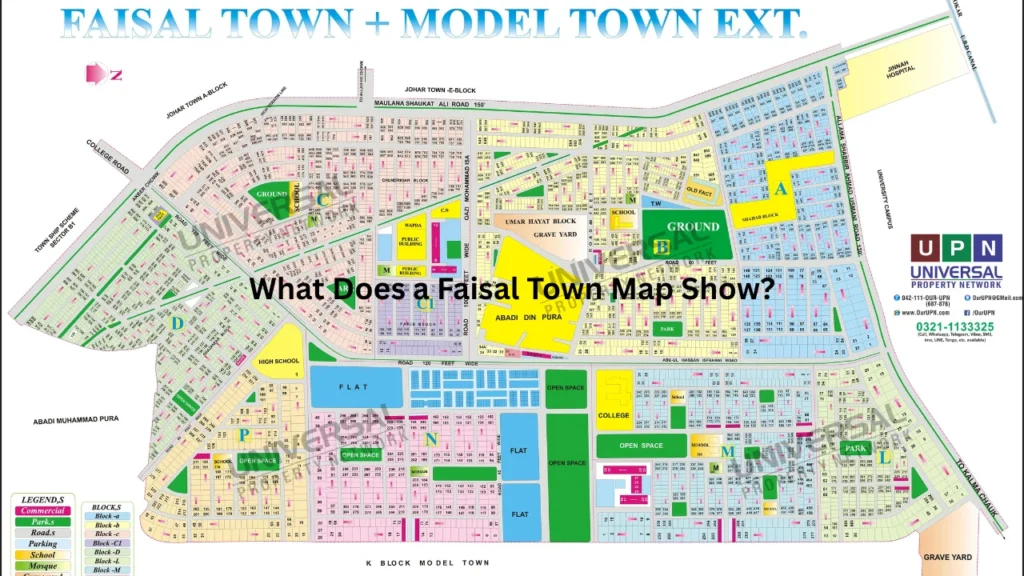
A society map gives a clear view of how planners have divided an area. It usually separates residential blocks, commercial zones, public facilities, roads, green spaces, and community areas.
A detailed map may also display plot numbers and street numbers. This information helps buyers locate a property without depending only on the description given by an agent or seller.
Some maps offer a simple road layout, while others provide an interactive satellite view. A master plan may show planned development that has not yet appeared on a live satellite image.
A useful map normally includes the following details:
| Map Feature | Information It Provides |
|---|---|
| Blocks | Names and boundaries of residential sections |
| Plot numbers | Position of individual residential or commercial plots |
| Main roads | Major routes connected to the area |
| Internal streets | Streets leading to houses and plots |
| Commercial areas | Markets, offices, shops, and business zones |
| Public facilities | Schools, mosques, parks, and health centres |
| Entry points | Main gates and alternative entrances |
| Nearby landmarks | Roads, societies, hospitals, and transport routes |
Faisal Town Map for Lahore and Islamabad
Users often search the same keyword for two different places. One is Faisal Town Lahore, an established residential and commercial neighbourhood. The other is Faisal Town Islamabad, also known as Faisal Town Phase 1 near the Islamabad-Rawalpindi region.
Faisal Town Lahore has long-developed streets, houses, markets, offices, schools, and public facilities. Its map mainly helps people find an existing address, business, house, or available property.
Faisal Town Islamabad includes planned housing blocks and plot layouts. Its map attracts buyers who want to check block locations, plot positions, road access, development areas, and nearby motorway connections.
Faisal Town Phase 2 represents another development in the Islamabad-Rawalpindi property market. Its master plan includes larger sectors, commercial districts, residential areas, broad roads, and planned public facilities.
Because these locations are different, users should add the city or phase name to their search. A specific search such as “Faisal Town Lahore Block C map” gives more useful results than a broad search.
Faisal Town Lahore Location
Faisal Town Lahore is a developed neighbourhood within the Gulberg area of Lahore. Its central position gives residents access to several major residential, educational, medical, and commercial locations.
The area connects with important city roads such as Maulana Shaukat Ali Road, Main Boulevard Faisal Town, Model Town Link Road, College Road, and routes leading toward Canal Road. Akbar Chowk also works as an important nearby junction.
Residents can travel toward Model Town, Garden Town, Township, Johar Town, and other central Lahore areas. Model Town Link Road directly connects Model Town with the Faisal Town and Township sides.
The location suits families, students, office workers, shop owners, and medical professionals. Many daily facilities sit within the area or at a short driving distance.
Faisal Town Map Lahore Blocks
The main Faisal Town map for Lahore divides the neighbourhood into four core residential blocks: Block A, Block B, Block C, and Block D. Each block has internal streets, residential properties, shops, mosques, parks, and access to nearby roads.
Some online property maps also show nearby extensions or separately listed sections. Users may see names such as C1 or neighbouring extension blocks, depending on the map provider and the boundaries included in the image.
Block A
Block A sits in a well-connected part of Faisal Town. Its streets provide access to nearby commercial activity, schools, clinics, mosques, and major roads.
Buyers should check the street number and plot position before visiting. Two plots in the same block can have different values due to road width, corner position, park facing, and distance from the main road.
Block B
Block B contains residential streets and active commercial areas. Its location makes it useful for people who want access to shops, food outlets, educational institutes, and public transport routes.
Traffic levels may change between internal streets and roads close to commercial activity. Families should compare peaceful residential streets with busier market-facing locations.
Block C
Block C appears separately on several property mapping services because buyers often search for its plot locations. The block contains developed streets, houses, and properties near key roads.
People checking a Block C property should compare the plot number with the official or approved layout. They should also visit the location to confirm the present road and surrounding construction.
Block D
Block D forms another important part of the neighbourhood. It provides residential access and connections toward surrounding Lahore localities.
A map can show the basic route, but a site visit gives more information about street condition, parking, traffic, shops, drainage, and nearby construction.
Major Roads Shown on the Lahore Map
Road access affects both daily life and property demand. Houses near a main road offer easier travel, but they may also face more traffic, noise, and commercial activity.
Main Boulevard Faisal Town runs between the Punjab University side and Akbar Chowk. Other nearby routes connect the neighbourhood with Model Town, Township, Garden Town, Johar Town, Ferozepur Road, and Canal Bank Road.
Maulana Shaukat Ali Road is another important route near the area. It supports movement toward Canal Road, College Road, Peco Road, and several nearby residential communities.
Users should study more than one possible route on the map. A shorter route may become slow during busy hours, while an alternative entrance may offer easier access.
Important Places Near Faisal Town Lahore
A local map becomes more useful when it shows nearby landmarks. Visitors can use a known hospital, university, market, road, or junction to find the correct block.
Punjab University’s New Campus lies near the wider Faisal Town and Garden Town area. Jinnah Hospital, Akbar Chowk, Model Town, Garden Town, Township, and Johar Town also serve as common location points.
The neighbourhood has access to supermarkets, restaurants, banks, schools, colleges, clinics, mosques, parks, and local markets. The exact distance depends on the block and street.
People searching for a rental house should check their daily destination on the map. A property may look central but still require a longer journey because of traffic or limited entry routes.
Faisal Town Islamabad Phase 1 Map
Faisal Town Phase 1 is a housing development in the Islamabad-Rawalpindi region. Search results commonly connect it with the F-18 area and access routes toward Rawalpindi-Kohat Road, GT Road, Srinagar Highway, and the motorway network.
The Phase 1 layout includes Block A, Block B, Block C, and Block B1. Blocks A, B, and C form the earlier sections, while B1 is a newer addition to the layout.
Its map displays residential plots, commercial areas, roads, parks, mosques, schools, and other planned facilities. Buyers use it to understand where a plot sits within the complete project.
Phase 1 should not be confused with Faisal Town Lahore. The two areas have different developers, road networks, plot systems, and property markets.
Blocks on the Faisal Town Islamabad Map
Block A
Block A provides one of the main access points within Phase 1. Its position makes it an important section for visitors entering the society.
Buyers often compare plots based on distance from the entrance, commercial area, park, mosque, and main boulevard. Corner and main-road plots may carry different prices from inner-street plots.
Block B
Block B connects with other developed parts of the society. The map helps buyers check street direction, plot rows, road width, and nearby facilities.
A buyer should not judge a plot only by its block name. The exact street and plot position can strongly affect accessibility, surroundings, and market demand.
Block C
Block C forms another major section of the Phase 1 layout. Its map can help residents plan routes toward the entrance and surrounding road network.
People should compare the approved layout with the property documents. They should also confirm that the plot number, street, size, and block match across all records.
Block B1
Block B1 lies next to Block B and connects with the wider Phase 1 network. Project information describes access through Block A and routes leading toward Rawalpindi-Kohat Road, GT Road, Srinagar Highway, and nearby motorway connections.
The block includes different residential plot categories. Since plans and development conditions can change, buyers should request the newest approved map before making a payment.
Faisal Town Map Phase 2 Overview
The Faisal Town map for Phase 2 shows a larger planned development with residential sectors, commercial areas, broad boulevards, parks, mosques, educational spaces, and healthcare facilities.
Project information places Phase 2 near the Thallian Interchange, M-2 Motorway, Chakri area, and planned Rawalpindi Ring Road connections. Its location attracts people who want motorway access and property options around the twin cities.
The master plan includes different blocks and named districts. Published layouts mention areas such as a Central Business District, Education City, commercial districts, Overseas sections, Model Blocks, and other planned sectors.
A master plan shows the planned shape of the project. It does not always prove that every road, facility, or district has reached the same stage of development.
Difference Between a Map and a Master Plan
Many buyers treat a map and a master plan as the same document. However, they can serve different purposes.
A location map shows where the housing project sits in relation to roads, cities, motorways, and nearby developments. It helps users understand regional access.
A block map gives a closer view of streets and plots inside one section. It may include exact plot numbers, road widths, green spaces, and commercial plots.
A master plan presents the complete planned layout. It may include future sectors, business districts, schools, parks, healthcare areas, and roads that are still under development.
A satellite map shows the visible condition of the land when the image was captured. It can help users compare planned roads with actual construction, but satellite images may not always be recent.
| Type of Map | Best Use |
|---|---|
| Location map | Checking access from nearby roads and cities |
| Master plan | Understanding the complete planned development |
| Block map | Finding streets, plots, parks, and markets |
| Satellite map | Viewing existing construction and surrounding land |
| Route map | Planning a drive or property visit |
How to Find a Plot on the Map
Start by collecting the correct block, street, plot number, and plot size. A plot number alone may not be enough because another block can use the same number.
Open the complete society layout before checking the block-level map. This step helps you understand the block’s position near entrances, roads, and nearby sections.
Next, zoom into the relevant block and find the street. Check the direction of the plot row and note any nearby park, mosque, commercial area, or main boulevard.
Match the map information with the allotment letter, transfer documents, or other property records. The spelling of the block, plot size, and plot number should remain the same.
Finally, visit the site with a person who understands the local plot markings. Physical verification can reveal land level, road condition, nearby construction, and access issues that a digital map may not show.
How Property Buyers Should Use the Map
A map can support property research, but it should not replace legal checks. Buyers should use it as one part of a wider verification process.
First, confirm whether the map comes from the developer, relevant authority, or a trusted property platform. Old marketing images may not include new blocks or revised roads.
Second, compare the plot location with possession and development information. A plot may appear in the master plan even when its street has not reached the same development stage as another section.
Third, check the distance from entrances and major roads. Easy access can improve daily travel, while plots deep inside a project may require more driving.
Buyers should also study the surroundings. A park-facing plot may offer an open view, while a commercial-facing property may receive more traffic and noise.
Important Checks Before Buying Property
The map gives location details, but buyers should complete several checks before making a final decision. These checks reduce the risk of confusion, false claims, and document problems.
Confirm the following information:
- Correct project, city, phase, block, street, and plot number
- Plot dimensions and total size
- Residential or commercial category
- Development and possession status
- Road width in front of the property
- Nearby park, mosque, market, or public facility
- Ownership, transfer, and allotment documents
- Approval or NOC status from the relevant authority
- Outstanding instalments, dues, or transfer charges
- Physical location through an on-site visit
An agent’s marked map can help explain the location. However, buyers should still compare it with an approved layout and original property documents.
Why Road Width and Plot Position Matter
Road width can affect movement, parking, construction access, sunlight, and property demand. Main-road plots may suit commercial activity, but they can also face heavier traffic.
Corner plots often provide access or open space on two sides. They may offer better airflow, but their building rules and price can differ from standard plots.
Park-facing properties may attract families because they offer an open view. However, buyers should check visitor traffic, parking, and activity around the park.
Plots close to an entrance reduce travel time, while inner plots may offer a quieter living environment. The right choice depends on the buyer’s budget and daily needs.
Common Mistakes When Reading the Map
The most common mistake involves opening the map of the wrong city. Faisal Town Lahore, Islamabad Phase 1, and Phase 2 represent separate locations.
Some users also depend on a low-quality image where street and plot numbers look unclear. A blurred number can lead them to inspect the wrong property.
Another mistake involves treating the planned map as proof of completed development. Roads, parks, commercial centres, and public facilities may appear in the plan before construction finishes.
People may also ignore direction and entrance points. Two nearby plots can require different routes because of street design, barriers, or limited access.
Users should check the map date whenever possible. A newer block, road, or revised section may not appear on an older copy.
How Residents and Visitors Can Plan Their Route
Residents can use a digital map to save their home, office, school, or shop location. A saved pin makes it easier to share an accurate destination with visitors and delivery drivers.
Visitors should ask for the city, block, street, and nearest landmark. A clear address such as “Block C, Faisal Town Lahore, near Main Boulevard” works better than the area name alone.
Property visitors should plan their journey during daylight. Daylight makes it easier to read plot markings, inspect roads, and understand the surrounding development.
Drivers should also compare routes before leaving. Construction work, traffic pressure, and road closures can change the fastest route.
Frequently Asked Questions
Which Faisal Town does the keyword usually refer to?
The keyword can refer to Faisal Town Lahore or Faisal Town Islamabad. Users should add the city, phase, and block name to find the correct layout.
How many main blocks are in Faisal Town Lahore?
Faisal Town Lahore has four core residential blocks: A, B, C, and D. Some mapping websites may also display nearby extensions or separately listed sections.
Which blocks appear in Faisal Town Islamabad Phase 1?
The Phase 1 layout includes Blocks A, B, C, and B1. Buyers should use a recent block map because newer additions may not appear on older images.
Can I verify property ownership through a map?
No. A map only helps identify the location and layout. Buyers must verify ownership, approval, dues, transfer records, and legal documents separately.
Is the master plan the same as the actual site condition?
Not always. A master plan shows the planned layout, while the actual site may have different levels of road, utility, and facility development.
Conclusion
A reliable map can help users understand blocks, roads, entrances, nearby places, and individual plot locations. It also helps buyers compare access, commercial activity, public facilities, and future development before arranging a visit.
Users must first confirm whether they need the Lahore, Islamabad Phase 1, or Phase 2 layout. They should then compare the map with property records and inspect the location in person. By using the correct Faisal Town map, buyers and visitors can avoid confusion and make better location-based decisions.
People Also Read: faisal town lahore map
