The khayaban e amin map helps buyers, residents, and investors understand the complete layout of this housing society in Lahore. It shows residential blocks, commercial areas, internal roads, parks, mosques, entrances, and nearby locations.
Khayaban-e-Amin is a well-known housing project located in the southern part of Lahore. Its location near Defence Road, Pine Avenue, Valencia Town, DHA Rahbar, Lake City, and Lahore Ring Road makes it accessible from different areas of the city.
A clear society map is important because Khayaban-e-Amin covers a large area and includes many blocks. Buyers can use the map to find a plot, check nearby facilities, study road access, and compare different locations before visiting the society.
You May Like: gulberg residencia map
What Is the Khayaban E Amin Map?
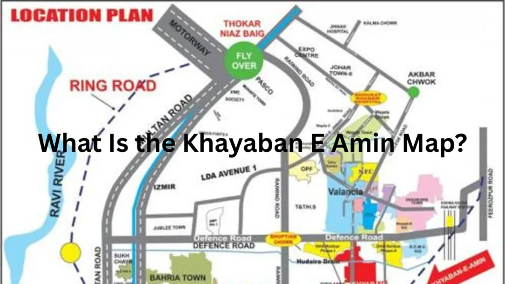
The khayaban e amin map is a detailed layout plan of the housing society. It divides the project into different blocks and shows how roads, plots, parks, commercial zones, and public facilities connect with one another.
Some maps provide a complete view of the society, while others focus on a single block. Block maps are often more useful because they may show street numbers, individual plots, road widths, green areas, and commercial sites.
A high-quality map can help a buyer understand whether a plot is located near a main boulevard, park, mosque, market, entrance, or boundary wall. This information can affect property value and daily living conditions.
Khayaban-e-Amin Location in Lahore
Khayaban-e-Amin is located near Defence Road in Lahore. It is positioned opposite Valencia Town and close to several developed residential communities.
The society also has access to Pine Avenue and Lahore Ring Road. These routes connect it with many important areas of Lahore and reduce travel time for residents.
Nearby housing projects and locations include Valencia Town, DHA Rahbar, Lake City Lahore, Halloki Gardens, Fazaia Housing Scheme, LDA Avenue, and Raiwind Road.
Its location makes the society suitable for people who work or study in different parts of southern Lahore. However, travel time can change depending on traffic and the block in which a person lives.
Main Features Shown on the Khayaban E Amin Map
A detailed khayaban e amin map contains several important features. These features help users understand the society before they visit it.
The map normally shows block names, plot numbers, internal streets, main roads, commercial areas, parks, mosques, educational sites, and society entrances.
| Map Feature | Purpose |
|---|---|
| Block names | Help users identify different parts of the society |
| Plot numbers | Show the exact location of a property |
| Internal roads | Explain how streets connect within each block |
| Main boulevard | Connects major areas of the housing project |
| Parks | Show green and recreational spaces |
| Commercial zones | Identify shops, markets, and business areas |
| Mosques | Help residents find nearby religious facilities |
| Entrances | Show the main access points of the society |
| Nearby societies | Explain the wider location of the project |
A complete map may also show graveyards, schools, community centres, utility areas, and reserved public spaces.
Major Roads Near Khayaban-e-Amin
Road access plays an important role in the value and convenience of a property. Khayaban-e-Amin has connections with several major roads in Lahore.
Defence Road
Defence Road is one of the main access routes for Khayaban-e-Amin. It connects the society with Valencia Town, DHA Rahbar, Raiwind Road, and other nearby areas.
Plots located near Defence Road may offer easier travel. However, they may also receive more traffic and road noise than plots located deeper inside residential blocks.
Pine Avenue
Pine Avenue is another important road near the society. It connects several housing projects and helps residents travel towards Raiwind Road and other growing parts of Lahore.
Buyers often prefer blocks with convenient access to Pine Avenue because it can make daily travel easier.
Lahore Ring Road
Lahore Ring Road improves connectivity between Khayaban-e-Amin and other major parts of Lahore. Residents can use nearby routes to travel towards DHA, Ferozepur Road, Multan Road, and the airport side.
Easy access to Ring Road can also increase property demand in nearby housing projects.
Main Boulevard
The Main Boulevard connects different parts of Khayaban-e-Amin. It usually carries more traffic than smaller residential streets.
Commercial properties, mosques, parks, and public facilities are often located near the main boulevard. Residential plots close to it may offer convenience but may also experience more activity.
Khayaban E Amin Map Block-Wise Details
The society is divided into several alphabetically named blocks. Each block has its own road network, plots, parks, and public spaces.
Commonly known blocks include A, B, C, D, E, G, K, L, M, N, P, Q, R, S, and T. The exact facilities and development conditions may differ from one block to another.
Blocks A, B, C, D and E
Blocks A to E are important residential sections of the society. These blocks contain different sizes of residential plots, internal streets, green areas, and public-use locations.
Some parts of these blocks are closer to the main entrance and Defence Road. This may provide better access for residents who travel daily.
Block-specific maps can help buyers find the exact street and plot number. They also show whether a property is near a commercial area, park, mosque, or main road.
Blocks G, K and L
Blocks G, K, and L form another major part of the housing society. These blocks contain residential streets and several planned community facilities.
Block L is known for residential plots and nearby green spaces. Families may prefer plots close to parks, but they should also check traffic and public activity around these locations.
Buyers should compare the official map with the actual site because development can differ between streets.
Blocks M and N
Blocks M and N include residential and commercial locations. Buyers often search these blocks because they may offer different plot sizes and price ranges.
A detailed map can help users check the distance from the main entrance, commercial markets, mosques, parks, and major roads.
The condition of roads, utilities, and nearby construction should also be inspected before buying a property.
Blocks P, Q, R and S
Blocks P, Q, R, and S cover a large part of the society. These blocks include residential plots, internal roads, commercial spaces, and public-use areas.
Block Q is often searched for larger residential plots. However, buyers should confirm the exact plot size and location through official documents.
Blocks R and S may offer quieter residential surroundings in some streets. Their distance from the main entrance can affect daily travel time.
Block T
Block T is also shown on complete society maps. It contains residential streets and planned facilities.
Buyers interested in this block should check road access, possession status, utilities, and nearby development before completing a purchase.
Residential Plot Sizes in Khayaban-e-Amin
Khayaban-e-Amin offers different residential plot sizes. Common options may include small, medium, and large plots.
| Plot Category | Common Sizes |
|---|---|
| Small residential plots | 3, 4, and 5 marla |
| Medium residential plots | 7, 8, and 10 marla |
| Large residential plots | 1 kanal or more |
| Commercial plots | Different sizes near markets and main roads |
Not every plot size is available in every block. Buyers should confirm the exact measurements through the approved layout and property documents.
Corner plots, park-facing plots, main-road plots, and plots near commercial areas may have higher prices. Their value depends on location, road width, possession, development, and market demand.
Commercial Areas on the Society Map
Commercial areas provide shops, grocery stores, restaurants, pharmacies, salons, property offices, and other daily services.
A property near a commercial market can offer convenience. Residents can easily buy household items and access important services.
However, commercial areas may also create more traffic, parking problems, and noise. Families looking for a peaceful environment may prefer plots located a short distance away from the market.
Investors often prefer commercial plots near the main boulevard, entrances, or busy residential blocks. These locations may receive more customer activity.
Parks and Green Spaces
Parks are an important part of the society layout. They provide open spaces for children, families, walkers, and older residents.
Park-facing plots often receive strong demand because they may offer a better view and more open space. However, such plots can also experience noise during busy hours.
Buyers should check whether a park shown on the map has been fully developed. A planned green area may not always have grass, walking tracks, lights, or play equipment.
A physical visit helps buyers understand the real condition of the park and its surrounding streets.
Mosques and Religious Facilities
Different blocks of Khayaban-e-Amin include mosques and reserved religious sites. These facilities make it easier for residents to attend daily prayers.
A plot near a mosque may be suitable for people who prefer walking access. However, buyers should consider parking, traffic, and noise during Friday prayers and religious events.
The map can help users estimate the distance between a plot and the nearest mosque.
Schools and Educational Facilities
Families often search for homes near schools and educational centres. The Khayaban-e-Amin area provides access to educational facilities within and around the society.
Nearby communities such as Valencia Town, Lake City, and DHA Rahbar also have schools, academies, and colleges.
Parents should check school distance, transport service, admission requirements, and fee structure before selecting a block.
The map provides a general idea of the location, but a site visit gives better information about travel time and road conditions.
How to Read the Khayaban E Amin Map
Reading the khayaban e amin map is simple when users follow the correct steps. First, locate the main entrance or the road through which you plan to enter the society.
Next, find the required block and follow the main boulevard towards its internal streets. After that, locate the street number and plot number.
Check whether the plot is close to a park, mosque, market, school, boundary wall, drain, or major road. These features can affect living conditions and property value.
Buyers should also check the direction of the plot. Some people prefer east-facing or west-facing properties based on sunlight and ventilation.
Always compare the map with the physical site. A map cannot show current construction, road damage, traffic, drainage, power lines, or street activity.
Why Different Maps May Show Different Details
Several versions of the Khayaban-e-Amin layout may be available online. Some maps provide only a general view, while others show complete plot numbers.
Older maps may not include new roads, revised commercial areas, completed parks, or changes in entrances.
Estate agents may also edit maps to highlight available properties. Such maps can be useful, but buyers should not treat them as official documents.
Always check the source and quality of the map. A clear block map is usually more helpful than a low-resolution image of the complete society.
Important Checks Before Buying a Plot
A society map only explains the location of a property. It does not confirm legal ownership or approval.
Buyers should check the seller’s documents, plot number, ownership record, transfer status, possession status, and unpaid charges.
| Verification Check | Importance |
|---|---|
| Ownership documents | Confirm that the seller owns the property |
| Plot number | Ensures the documents match the location |
| Transfer status | Confirms whether the property can be transferred |
| Possession status | Shows whether construction can start |
| Development charges | Identifies any unpaid fees |
| Utility availability | Confirms water, electricity, gas, and sewerage |
| Physical measurement | Checks plot size and boundaries |
| Official approval | Helps confirm the legal status of the property |
A buyer should never depend only on an advertisement, map, or property dealer. Legal and official verification can protect the buyer from fraud and future problems.
Benefits of Using an Updated Map
An updated society map can save time during the property search. It allows buyers to compare several blocks before arranging site visits.
Investors can study road access, nearby construction, commercial activity, parks, and distance from major routes.
Residents can use the map to find the closest entrance, mosque, market, park, or main road.
Overseas buyers can also use a detailed map to understand the location. However, they should ask a trusted person to visit the site and confirm all documents before payment.
Is Khayaban-e-Amin Suitable for Families?
Khayaban-e-Amin may suit families who want to live in the southern part of Lahore. The society offers residential blocks, parks, mosques, commercial areas, and access to nearby schools.
Its location near Defence Road, Pine Avenue, Valencia Town, Lake City, DHA Rahbar, and Ring Road adds convenience.
However, conditions may differ between blocks. Families should inspect road quality, security, streetlights, drainage, water supply, electricity, gas availability, and nearby construction.
Visiting the area during both daytime and evening can provide a better understanding of traffic, safety, and community activity.
Frequently Asked Questions
Where is Khayaban-e-Amin located?
Khayaban-e-Amin is located near Defence Road in Lahore. It is close to Valencia Town, DHA Rahbar, Lake City, Pine Avenue, and Lahore Ring Road.
What does the society map show?
The map shows blocks, roads, plots, parks, mosques, commercial areas, entrances, and nearby locations.
Can I find my plot number on the map?
A detailed block map may show individual plot numbers and street numbers. A general society map may only show blocks and major roads.
Does the map prove legal ownership?
No. A map only shows the location of a plot. Buyers must check ownership and legal documents through the relevant offices.
What should I check during a site visit?
Check road condition, plot location, street width, utilities, drainage, security, parks, markets, and nearby construction.
Conclusion
The khayaban e amin map is a useful tool for understanding the complete layout of the housing society. It helps users locate blocks, plots, roads, parks, mosques, commercial areas, entrances, and nearby landmarks.
However, buyers should not make a property decision based only on a map. They should visit the location, compare the plot with official documents, inspect development conditions, and complete legal verification before making any payment.
People Also Read: faisal town map
