A Model Town Lahore map helps residents, visitors, property buyers, and delivery drivers understand one of Lahore’s best-known planned neighbourhoods. It shows the main blocks, circular roads, entry points, commercial markets, parks, schools, hospitals, and routes connecting Model Town with other parts of the city.
Model Town has a clear and organised layout, but new visitors may still find its circular roads and similar block names confusing. A detailed map makes it easier to locate an address, select the right entrance, plan a driving route, or compare properties in different blocks.
You May Like: gulberg residencia map
Understanding the Model Town Lahore Map
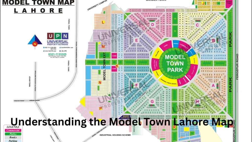
Model Town is a planned residential neighbourhood located near Ferozepur Road in Lahore. Its original society area has a balanced design with a large circular park near the centre and residential blocks arranged around it.
The neighbourhood covers about 1,463 acres, or nearly 5.9 square kilometres. Its land includes residential plots, commercial areas, roads, playgrounds, nurseries, and green spaces.
The original Model Town Society contains ten blocks:
| Original blocks | Area type |
|---|---|
| A Block | Residential and local commercial area |
| B Block | Residential area with parks and sports grounds |
| C Block | Residential and major commercial activity |
| D Block | Residential area and sports facilities |
| E Block | Residential streets and local market |
| F Block | Residential area, library and Link Road access |
| G Block | Residential and commercial access |
| H Block | Residential area |
| J Block | Residential area |
| K Block | Residential area |
The design follows the idea of a garden town. Roads divide the neighbourhood into blocks while green spaces, markets, mosques, and playgrounds support daily community life.
Model Town Lahore Map Block-Wise Layout
The block system is one of the most important details shown on a Model Town Lahore map. Each block has numbered or named streets, residential plots, small parks, mosques, and local shops.
Although the blocks share a similar layout, their locations affect access to major roads, markets, schools, and public facilities. Understanding each block can help a visitor avoid taking a longer route.
A Block
A Block lies in the planned society area and includes calm residential streets. It offers access to nearby markets, green spaces, and roads leading toward the outer parts of Model Town.
People searching for an address in A Block should also check the house number, street number, and nearest landmark. This information is important because one block may contain several roads with similar turns.
B Block
B Block includes residential streets, parks, and sports areas. The B Block ground is also connected with local football activities and community recreation.
A map can help visitors locate the correct side of B Block without circling the central park. It is useful to identify the nearest entrance before starting the journey.
C Block
C Block is one of the busiest parts of Model Town because it includes Bank Square Market, also called C Block Market. The area has banks, restaurants, shops, offices, and other commercial services.
Traffic may become slow near the market during busy hours. Visitors should use a live navigation application to check the current road conditions before travelling.
D Block
D Block contains residential streets and recreational facilities. The D Block football ground is a recognised sports location within the community.
Its position near Model Town’s internal road system makes it reachable from different directions. However, selecting the correct entrance can reduce unnecessary driving.
E Block
E Block mainly serves residential needs. It includes local streets, green areas, a mosque, and shops that support people living nearby.
Visitors should save the complete address rather than searching only for “E Block Model Town.” A house number or nearby business name will provide a more accurate result.
F Block
F Block is important because of its access to Model Town Link Road and the presence of the Model Town Library. The library has long served local readers, students, and researchers.
Link Road connects the Model Town area with nearby commercial and residential locations. It is one of the busiest routes around the society.
G Block
G Block sits close to Link Road and includes both residential and commercial movement. Navigation services identify sections of Model Town Link Road around G Block and F Block.
People travelling to G Block should check whether their destination lies inside the society or on the Link Road side. This small detail can change the best driving route.
H, J and K Blocks
H, J, and K Blocks form other parts of the original Model Town Society. They contain residential streets, neighbourhood parks, mosques, and small shopping areas.
These blocks may appear close to one another on a map, but internal roads and barriers can affect direct access. Following the marked road instead of taking an unverified shortcut is usually safer.
Model Town Extension Blocks
A complete map may also show several blocks outside the original society. These include L, M, N, P, Q, R, and S Blocks.
These areas are commonly linked with Model Town Extension and are administered separately from the ten original society blocks. Historical accounts state that this land passed to the Lahore Development Authority in return for development work.
Property platforms may list individual maps for many original and extension blocks. For example, available society-map listings include A, B, C, D, E, F, G, H, J, K, Q, R, and S Blocks.
People buying or renting property should confirm whether an address belongs to Model Town Society, Model Town Extension, or a nearby area using a similar name.
Main Roads Shown on the Model Town Lahore Map
Road connections are an important part of any local map. Model Town connects with major routes that help residents travel toward central Lahore and nearby neighbourhoods.
Ferozepur Road
Ferozepur Road is one of Lahore’s major roads and provides important access to Model Town. Property guides describe the society as being located near Main Ferozepur Road.
This route links the area with several business districts, public transport points, hospitals, educational institutions, and other parts of Lahore.
Model Town Link Road
Model Town Link Road connects Model Town with areas such as Faisal Town and Township. Shops, restaurants, offices, and service businesses operate along both sides of the road.
It is an active commercial route, so traffic conditions can change throughout the day. Online maps and live traffic tools help drivers select the best approach.
Circular Roads
Model Town’s planned design includes circular roads around the central park and within the society. These roads support movement between different blocks.
The circular pattern looks simple on a printed map. However, drivers can miss the correct turn if they do not know which block or gate is closest to the destination.
Internal Streets
Each block contains smaller residential roads and connecting streets. These roads lead toward houses, markets, mosques, parks, schools, and community facilities.
Some internal roads may have barriers or controlled entry. Drivers should follow official signs and avoid routes that pass through closed access points.
Main Entrances and Access Points
Model Town has several entrances connecting it with surrounding roads. The most suitable entrance depends on the destination block and the direction from which a person is travelling.
Common access points include entrances from:
| Access side | Useful for reaching |
|---|---|
| Ferozepur Road | Blocks near the main road and central society |
| Model Town Link Road | F and G Blocks, markets and nearby extension areas |
| Mariyan side | Nearby residential sections |
| Arfa Karim Park side | Routes approaching from surrounding areas |
Reports about the society’s security system state that barriers are used at several exits. Four major entrances have traditionally remained available around the clock, including the Ferozepur Road, Link Road, Mariyan, and Arfa Karim Park entrances.
Access rules can change, so visitors should follow current signs and security instructions. A navigation application may show a road that is not open for general entry at that time.
Model Town Park on the Map
Model Town Park is the most recognisable landmark in the neighbourhood. It lies near the centre and plays an important role in the circular layout of the society.
The park covers around 125 acres and includes green lawns, a lake, walking space, a playground, and a circular jogging track. It attracts residents from Model Town and nearby parts of Lahore.
The central park also works as a useful navigation point. A person can first identify the park and then locate the required block around it.
Visitors should still search for the correct park entrance. Reaching the park boundary does not always mean the main gate or parking area is nearby.
Important Markets and Commercial Areas
Commercial locations help people identify directions more easily. Model Town has block markets, neighbourhood shops, banks, restaurants, and larger shopping roads.
Bank Square Market
Bank Square Market in C Block is one of the main commercial areas. It includes many banks, eateries, offices, pet shops, and other businesses.
People often use this market as a meeting point or landmark. However, visitors should search for the exact shop or bank because the commercial area covers several streets.
Model Town Link Road Market
Link Road is known for its wide range of shops and services. Visitors can find clothing stores, restaurants, electronics shops, pharmacies, bakeries, and household businesses along the road.
This area often receives more traffic than the quiet streets inside the society. Parking may also require extra time during evenings and weekends.
Local Block Markets
Most blocks have smaller markets for daily needs. These may include grocery shops, bakeries, pharmacies, salons, food outlets, and other local services.
A block market can be a helpful landmark when locating a house. Users should enter the market name and block name together for better map results.
Schools, Libraries and Community Facilities
Model Town contains several educational and community institutions. These places often appear as key points on digital maps.
Schools and colleges in or near the area include Divisional Public School, Lahore Grammar School, The City School, government schools, colleges, and other private institutions.
The Model Town Library is located in F Block. Sports grounds, football clubs, cricket facilities, mosques, parks, and community clubs also serve local residents.
When searching for an institution, users should check its full name and branch. Some schools and businesses operate more than one campus in Lahore.
Nearby Areas Around Model Town
A local map also helps users understand the neighbourhoods surrounding Model Town. Nearby areas include Faisal Town, Garden Town, Township, Kot Lakhpat, Model Town Extension, and other parts of southern Lahore.
Link Road supports travel toward Faisal Town and Township, while Ferozepur Road provides access toward many central and southern locations.
Travel times depend on traffic, roadwork, weather, and the selected entrance. Therefore, users should avoid relying only on straight-line distance.
How to Use Google Maps for Model Town
Digital maps provide more detail than a simple printed image. They can show satellite views, live traffic, business names, customer reviews, road closures, and estimated travel times.
Follow these steps for a better search:
- Enter the full block and street address.
- Add the house, plot, office, or shop number.
- Check the destination pin before starting.
- View the satellite layer for nearby landmarks.
- Select the entrance closest to the destination.
- Share the live location when meeting another person.
- Check traffic before travelling during busy hours.
Search results for local map services also provide dedicated location and satellite views for Model Town. Property-map platforms allow users to study block layouts and identify existing or future property locations.
Using a Map for Property Search
A map is useful for buyers, renters, agents, and investors. It helps them compare a property’s position with nearby roads, parks, schools, markets, and commercial areas.
Before selecting a property, study the following details:
| Map detail | Why it matters |
|---|---|
| Block location | Shows the property’s general position |
| Main road distance | Affects travel and noise |
| Park access | Supports recreation and family needs |
| Market distance | Makes daily shopping easier |
| Entry point | Affects travel time |
| School access | Important for families |
| Commercial activity | May affect traffic and privacy |
| Street width | Influences parking and access |
A digital pin should not replace legal property documents. Buyers must confirm plot numbers, ownership records, boundaries, approvals, and society information through proper authorities.
Punjab’s digital land map system also explains that online property lines are indicative and should not be treated as final legal boundaries.
Benefits of Using a Model Town Lahore Map
A map can improve travel planning and reduce confusion. It provides a clear picture of blocks, road connections, green spaces, and nearby facilities.
It is useful for:
- Finding a house or business
- Choosing the nearest entrance
- Planning a delivery route
- Comparing property locations
- Locating markets and schools
- Reaching Model Town Park
- Checking nearby neighbourhoods
- Avoiding unnecessary turns
- Sharing an accurate location
Printed maps provide a helpful general view, while digital maps provide live directions. Using both can be useful when someone is visiting the area for the first time.
Common Navigation Mistakes
One common mistake is searching only for “Model Town Lahore.” This search covers a large area and may not lead to the exact street.
Another mistake is confusing original Model Town blocks with Model Town Extension. Users should check the block letter and nearby landmark carefully.
Some drivers also follow shortcuts through residential streets without checking barriers. It is better to use recognised entrances and follow current road signs.
People should also avoid trusting an old screenshot without checking recent map information. Businesses may move, entrances may change, and traffic routes may be updated.
Frequently Asked Questions
How many blocks are in the original Model Town Society?
The original society has ten blocks: A, B, C, D, E, F, G, H, J, and K. Other blocks are generally linked with Model Town Extension.
Where is Model Town located in Lahore?
Model Town is located near Ferozepur Road and connects with areas such as Faisal Town, Township, Garden Town, and Model Town Extension.
Which is the main commercial market in Model Town?
Bank Square Market in C Block is one of the main commercial centres. Model Town Link Road is also a major shopping and business area.
What is the biggest landmark in Model Town?
Model Town Park is the most visible landmark. Its central location and circular shape make it easy to identify on a map.
Can a map be used to verify a property boundary?
A map can help identify the general location, but it should not serve as legal proof. Buyers must verify property records and boundaries through official documents and authorities.
Final Thoughts
A detailed Model Town Lahore map makes it easier to understand the neighbourhood’s blocks, circular roads, markets, parks, entrances, schools, and nearby areas. It is helpful for local residents, first-time visitors, delivery workers, and people searching for property.
For the best results, enter the complete address, confirm the block, check the nearest landmark, and use live traffic directions. A correct map search can save time, prevent wrong turns, and make travelling through Model Town much easier.
People Also Read: lake city lahore map
