The Lake City Lahore Map helps buyers, residents, and investors understand the complete layout of this well-planned housing community. It shows major sectors, internal roads, residential plots, commercial areas, parks, landmarks, and entry points.
Lake City Lahore sits on Main Raiwind Road and offers direct access through the Lahore Ring Road interchange. A clear map makes it easier to compare sectors, check nearby facilities, locate a plot, and plan a visit before making a property decision.
You May Like: khayaban e amin map
What Does the Lake City Lahore Map Show?
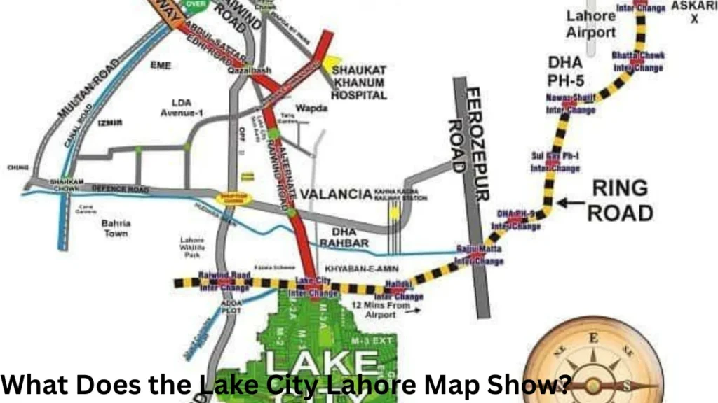
The master plan gives a broad view of the society and its different sections. It helps users see how residential sectors connect with commercial zones, main boulevards, parks, mosques, schools, and recreational areas.
A detailed map may also show plot numbers, road widths, block boundaries, corner locations, park-facing plots, and commercial plots. However, the amount of detail can differ between the main society map and individual sector maps.
Online map collections list separate layouts for M1, M2, M2-A, M3, M3-A, M3 Extension, M4, M5, M7, M7-C, M7-D, M8, Golf Estate, Golf View, and the Central Business District.
This is why buyers should not depend on a small or unclear image. They should use a high-resolution map and confirm the latest plot details with the official management before completing a deal.
Location of Lake City Lahore
Lake City Lahore is located at approximately 13 kilometres on Main Raiwind Road, Lahore. Its position places it near several important routes and growing residential areas.
The Lake City Ring Road Interchange provides direct access to the Lahore Ring Road. This connection helps residents travel toward DHA, Ferozepur Road, the motorway network, the airport side, and other parts of Lahore.
Main Raiwind Road also acts as a major access route. People travelling from Thokar Niaz Baig, Adda Plot, Raiwind, or nearby societies can use this road to reach the project.
The location is important because accessibility can affect daily travel, rental demand, business activity, and long-term property interest. A sector close to an entrance may provide faster travel, while an inner sector may offer a quieter living environment.
Lake City Lahore Map Sector Guide
Lake City includes several main sectors and extensions. Official project information divides much of the development into two broad parts called Bella Vista and Bella Verde.
Bella Vista includes the earlier sectors from M1 to M7, along with M7-A and M7-B. Bella Verde includes newer areas such as M7-C and M8. Some property maps also show extensions and smaller blocks as separate locations.
The following table gives a simple overview of important sectors:
| Sector | General Map Position or Feature | Suitable For |
|---|---|---|
| M1 | Located near Lake City Mall and commercial facilities | Families seeking central access |
| M2 | Positioned near the right side of the Ring Road entrance | Buyers who value quick road access |
| M3 | Located near the left side of the Ring Road entrance | Residential living with connectivity |
| M4 | Includes Golf Estate and Golf View areas | Golf-facing and premium living |
| M5 | Located opposite Lake City Mall | Access to shopping and daily facilities |
| M6 | Positioned around the mall and commercial zone | Central community living |
| M7 | Large residential area with several blocks | Different plot sizes and family housing |
| M7-C | Part of the newer development area | Modern villas, plots and townhouses |
| M8 | A newer residential sector with wide roads | Families and long-term buyers |
The exact position of a plot depends on its block and plot number. Buyers should open the relevant sector map rather than relying only on the main master plan.
Sector M1 on the Master Plan
M1 is one of the established areas shown on the society map. It sits close to Lake City Mall and provides convenient access to shopping, dining, parks, and other community facilities.
The sector includes residential options in different sizes. Its location can suit families who want to remain close to active commercial areas without leaving the gated community.
When studying an M1 map, check the distance between the selected plot and the main boulevard. Also review its position near parks, commercial streets, mosques, and sector entry points.
Sectors M2 and M3
M2 and M3 hold important positions near the Lake City Ring Road entrance. Official sector information places M2 on one side of the entrance and M3 on the other.
These sectors can attract buyers who frequently travel outside the society. A shorter route to the interchange may reduce daily travel time and make property access easier for visitors.
Individual maps may also list M2-A, M3-A, M3-B, M3 Extension, and M3 Extension 1. These names matter because two plots with similar numbers may belong to different extensions.
Always check the full sector and block name on the allotment or transfer documents. A plot number alone may not provide enough information for correct identification.
Sector M4, Golf Estate and Golf View
M4 is one of the most recognised areas in the Lake City master plan because it includes golf-related residential zones. The official project description connects this part of the society with the large golf course and scenic surroundings.
A golf-facing plot may differ from a standard inner plot in terms of location, view, surroundings, and market demand. The map helps a buyer check whether a property actually faces the golf course or only sits within the wider M4 area.
Buyers should also inspect nearby roads and open spaces. A good view may be attractive, but road access, plot shape, construction rules, and distance from daily facilities also affect practical value.
Sectors M5 and M6
M5 is located opposite Lake City Mall, while M6 surrounds parts of the mall and commercial area. These positions give both sectors access to shopping, food outlets, and community services.
People who prefer a central location may consider these sectors. However, plots closer to commercial activity may experience more traffic than plots located deeper inside a residential block.
The sector map can help users compare central plots with quieter internal plots. It also shows the routes residents can use to reach the main boulevard and other parts of the society.
Sectors M7, M7-C and M8
M7 is a large part of Lake City Lahore and contains several blocks and subdivisions. Some map platforms list M7, M7-C, and M7-D separately, while official project information also refers to M7-A and M7-B.
Because M7 covers a broad area, buyers should always request the exact block map. The main society plan may not clearly display every plot number, street, park, or commercial location.
M7-C belongs to the newer Bella Verde section. Official information links this area with family recreation and newer residential development.
M8 also offers plots and villas within a modern road network. The official project website describes M8 as a sector with modern infrastructure, wide avenues, parks, underground electricity, and nearby facilities.
Important Roads and Entry Points
Road access is one of the most useful details on any housing society map. Lake City Lahore has access from Main Raiwind Road and a direct interchange connection with the Lahore Ring Road.
Internal boulevards connect the main entrance with residential sectors, commercial areas, parks, and community facilities. Smaller streets then provide access to individual plots and houses.
When checking a property, study the number of turns between the plot and the nearest entrance. A plot may appear close to an interchange in a straight line but require a longer drive through internal streets.
Buyers should also check whether a plot sits on a main boulevard, a secondary road, or an internal street. Main-road plots may offer better access, but they can also receive more traffic and noise.
Commercial Areas on the Map
Lake City includes different commercial destinations rather than one small market. The official project information identifies Business Bay District, Central Commercial Boulevard, and Canal Commercial as important business areas.
Lake City Mall serves as a major shopping and entertainment location within the community. It includes local and international brands, restaurants, and stores for daily needs.
A property near a commercial area may suit buyers who value convenience. Such locations can provide quicker access to groceries, restaurants, offices, and retail services.
However, residential buyers should also consider parking, traffic, noise, and privacy. The society map helps them choose a balanced location near commercial facilities without sitting directly inside a busy zone.
Parks, Golf Course and Open Spaces
Green areas form an important part of Lake City Lahore’s planning. The project contains landscaped parks, open spaces, jogging areas, and recreational facilities across different sectors.
Official project information states that the society has more than 40 landscaped parks. It also describes wide roads and green surroundings as major parts of the community design.
The golf course acts as another major landmark on the master plan. Properties near Golf Estate and Golf View may attract buyers who prefer open views and a premium environment.
Park-facing plots may also receive greater buyer interest. Before paying an additional amount for a park-facing location, confirm the park on the approved map and visit the site.
Community Facilities and Amenities
The society map can help residents locate facilities needed for daily life. These may include schools, mosques, healthcare services, shopping centres, restaurants, parks, clubs, and entertainment spaces.
Official information mentions Lake City Mall, educational institutions, healthcare facilities, the Grand Jamia Mosque, dining outlets, and recreational areas within the community.
Lake City also promotes underground electrification, wide roads, controlled entrances, CCTV monitoring, and round-the-clock security. Many residential areas have nearby parks, sector mosques, and commercial spaces.
These features can improve daily convenience, but their distance differs from sector to sector. A map allows families to select a location based on their own needs, such as school access or a nearby park.
How to Use the Lake City Lahore Map Before Buying
Start by confirming the complete property details. Ask for the sector, block, plot number, plot size, street number, and nearby landmark.
Next, find the plot on a clear sector map. Check its direction, road width, shape, and position compared with parks, commercial areas, mosques, entrances, and the Ring Road interchange.
After checking the map, visit the site in person. A map cannot always show the current road condition, nearby construction, ground level, traffic, or development activity.
Compare the map with the official property documents. Make sure the sector, block, dimensions, and plot number match the seller’s information.
You should also ask whether the plot has any special category. Corner, park-facing, main-boulevard, golf-facing, or commercial plots may follow different prices and conditions.
Finally, confirm the latest ownership record, transfer status, dues, development charges, and construction rules through authorised sources. Do not make a decision only because an online map marks a location as attractive.
Difference Between a Master Plan and a Plot Map
A master plan gives a broad view of the complete housing society. It normally shows sectors, main roads, major commercial areas, green zones, entrances, and large landmarks.
A plot map provides more detailed information about one sector or block. It may display plot numbers, street layouts, road widths, parks, corner plots, and commercial plots.
Both maps serve different purposes. The master plan helps users understand the overall location, while a plot map helps them inspect a specific property.
For serious property research, buyers should use both versions. They should begin with the main master plan and then open the detailed map of the selected sector.
Why Map Details May Change
Housing societies may update layouts as development continues. A new extension, road adjustment, commercial zone, or block division may appear in a newer version of the map.
Different property websites may also use maps from different periods. One platform may list an extension separately, while another may include it under the main sector name.
For this reason, treat online maps as research tools rather than final legal proof. Always request the latest approved layout and verify the plot through the society’s official office.
This step becomes more important when buying in an extension, a recently developed block, or an area where possession and construction activity are still progressing.
Benefits of Studying the Map Carefully
A map can save time during property research. It allows buyers to remove locations that do not match their travel, budget, or lifestyle needs.
It also helps investors compare access, nearby development, commercial activity, and future demand. Locations near major roads may suit some buyers, while park-facing or quieter internal streets may suit others.
Families can use the map to check schools, mosques, parks, shopping areas, and healthcare access. Commercial buyers can study road connections, surrounding population, and customer movement.
Most importantly, a detailed map reduces confusion. It helps buyers ask better questions before visiting the site or speaking with a property agent.
Frequently Asked Questions
Where is Lake City Lahore located?
Lake City Lahore is located on Main Raiwind Road. It also has direct connectivity through the Lake City Lahore Ring Road Interchange.
Which sectors are shown on the Lake City map?
Commonly listed sectors include M1, M2, M2-A, M3, M3-A, M4, M5, M6, M7, M7-C, M7-D, and M8. Some maps also show extensions, Golf Estate, Golf View, and commercial districts separately.
Does the main map show individual plot numbers?
The main master plan may not show every plot number clearly. Users often need a separate sector or block map to find an individual plot.
Which sectors are close to the Ring Road entrance?
Official sector information places M2 and M3 near the Ring Road entrance. The exact travel distance depends on the selected block and internal road route.
Can buyers rely only on an online map?
No. Buyers should use an online map for initial research and then verify the location, documents, ownership, dues, and approved layout through authorised sources.
Conclusion
A clear Lake City Lahore Map provides valuable information about sectors, roads, residential blocks, commercial areas, parks, entry points, and major community facilities. It helps families compare living locations and allows investors to understand access and surrounding development.
However, users should always check the latest sector map, visit the site, and confirm property documents before making a payment. Careful map research, official verification, and a physical inspection can help buyers make a safer and more informed decision.
People Also Read: faisal town map
